This posting is from BeaV in person
I am no longer doing, I am planning again...err! I landed in Skagway last Tuesday and got down to eating food, reorganizing and getting rid of any gear not needed, and determined to start the Chilkoot Trail on Friday. Thursday I checked in with the National Park Service here, as required, to register and notify Canadian Customs of my intentions. To my dismay, I was informed of difficult conditions ahead and was told to come back so we could meet again with the chief ranger. I was informed that April here was historically the coldest on record with heavy snow up high that hadn't started melting until the day I arrived. Avalanche conditions were extremely high as temperatures rose here into the 60's with sunny conditions. I would be the 1st up there and noone would follow including rangers. I was advised not to try. So I felt terrible that my hard paddling seemed to be wasted. I scrapped Plan A and needed to do more thinking. I spent the rest of Thursday and Friday trying to learn what lay ahead. I want to thank the people at the Park Service and Packer Expeditions for their help on this. Packer Expeditions does guided day trips around the area including the Chilkoot as well as retailing proper gear to do it. I made the decision to move forward with the hike but at a slower careful pace and ready to sit tight if things get hairy.
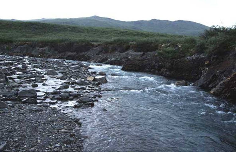
Friday night I hiked a local trail to test how weak my "sea legs" were. Not bad! Saturday I wanted to scout canoe access to the Chilkoot via the Taiga River and then scout the lower trail itself. I had read that other kayakers in the past were able to paddle up to the trailhead but no further. I planned my approach to the Taiga River near high tide which put me there at about 1:00 pm. Worked my way up the Taiga to the trailhead (milepost 0) and decided to try a little further [I have that problem:)]. Went another 2 miles by paddling harder and sometimes pulling the canoe. Loaded up my backpack with half of my gear and started hiking the Chilkoot. Felt really good to be making progress. Made it to the second camp called Canyon City at milepost 7.8. Trail conditions were becoming snowier as I approached Canyon City as expected after my education from the Park Service. Stashed gear in the bear boxes and made it back to Skagway at 10:30 pm. My Plan B was now to leave today (Monday) with extra food provisions to last 3 weeks and make the portage with 3 trips. No way to avoid 3 trips now with extra snow gear and way more food. It will now be 165 miles total hiking to get to Lake Bennett. Conditions not good on the Yukon side either. The Yukon lakes and almost all of the river at least down to Dawson (about 700 miles) is still frozen. But I would rather get to the other side and wait than here.
So last night after attending evening mass at the local Catholic church, I met a local named Doug who has lived here since 1966, has vast expertise in the high country, and was at 6000' snowmobiling on a glacier a few days ago having a great view from above of the Chilkoot Pass area. So here comes another sucker punch to the stomach- avalanche conditions are the worst he's ever seen without a question. Avalanches are coming down in areas he's never seen before with all kinds of snow still up high hanging there ready to come down. He also said that snow conditions on the Canadian side are deep, soft, and wet that will not support my weight even with snowshoes. It's a whole different, nasty world up there right now that can't be seen from sealevel. Doug said fate brought us together last night and he saved my life. I won't disagree. I went to mass largely because I had a "bad" feeling and Doug hasn't attended mass for years. Glad our paths crossed. So now I need a Plan C. I must admit I am enjoying Skagway and the good people here but it's hard not to be moving forward.
Read as Bob Vollhaber (aka BeaV) prepares for and attempts a continuous, unsupported 5000 mile canoe adventure to, through, and around Alaska by paddle.
Quote:
"Nothing in the world can take the place of persistence.
Talent will not; nothing is more common than unsuccessful men with talent.
Genius will not; unrewarded genius is almost a proverb.
Education will not; the world is full of educated derelicts.
Persistence and determination alone are omnipotent."
Calvin Coolidge
Talent will not; nothing is more common than unsuccessful men with talent.
Genius will not; unrewarded genius is almost a proverb.
Education will not; the world is full of educated derelicts.
Persistence and determination alone are omnipotent."
Calvin Coolidge
Inside Passage
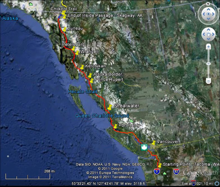
The above map depicts my planned paddle route along the Inside Passage
Yukon/Alaska Overview
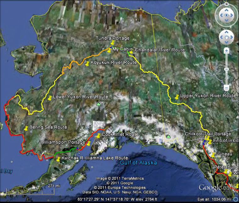
The above map depicts my planned paddle & portage routes through the Yukon Territory and Alaska
Adventure Description- Inside Passage and Chilkoot Portage
Route Description Overview: I have broken down the Adventure into eleven sections or "legs"each with distinctly different characteristics. The first and longest leg will be to paddle up the pacific coast of Washington State, British Columbia, and SE Alaska (Inside Passage); then portage up and over the coastal mountain range (Chilkoot Pass); then paddle down 900 miles of the Yukon River to the Chandalar River; then paddle/pull up the Chandalar River to it's source; then bushwack portage over some tundra to find the Koyukuk River and stop by my old cabin; then paddle down the Koyukuk to the Yukon River again; then paddle down the rest of the Yukon River to the Bering Sea; then hang a left and paddle the Bering Sea along the SW coast of Alaska to the Kvichak River; then paddle up the Kvichak River to and through Iliamna Lake; then portage through the Alaskan Pennisula mountain range to Cook Inlet; and then, lastly, paddle along the coastline of the Cook Inlet to Anchorage. Determination, persistance, wise decision making, and a little luck will be needed to do the entire route in one season before freezeup.
A more detailed description of each of the eleven legs of the Adventure follows below.
Inside Passage Paddle and Chilkoot Portage:
The Adventure will commence around March 24, 2013 near Bellingham Washington. The first leg of the trip will be paddling up the coasts of British Columbia and southeast Alaska on the route known as the "Inside Passage". The Inside Passage is a 1,300 mile long shipping route from Washington to Skagway Alaska that winds through thousands of islands and provides protection from the sometimes violent sea conditions encountered along the outside passage of the Pacific Ocean. The coastline's climate is that of a temperate rainforest with rugged slopes meeting the ocean and large tidal fluctuations. Expected challenges will be cold oceanwater temperatures, persistant rainfall, high winds, tidal currents, and limited landing sites for resting and protection from wind/storms. This segment will end near Skagway Alaska where the second leg of the Adventure will require portaging canoe and gear along the Chilkoot Trail and over the Chilkoot Pass.
The Chilkoot Trail is a 32-mile trail through the mountains that leads from Dyea, Alaska, just outside Skagway, to Lake Bennett in British Columbia. The trail, which crosses the historic Chilkoot Pass (a 3500 vertical foot climb), was the major access route to the Yukon goldfields during the Klondike Gold Rush that hit its peak in 1897-1899. It was at this time that the Chilkoot Pass earned the nickname "the meanest 32 miles in the world." Expected challenges will be physical (see previous sentence!) compounded by spring trail conditions likely to include mud in the lower elevations and deep, soft snow fields in the higher elevations. My goal is to be able to carry my gear and canoe in two trips (which will equal 96 miles of portaging) in a total of 6 days.
Chilkoot Pass

Historical photo of gold rush "Klondikers" (the long black line) climbing toward the Pass
Adventure Description- Upper Yukon River
Upper Yukon River Paddling Route:
I will begin my paddling on the Yukon River at it's source which is in part Lake Bennett after the Chilkoot Pass. I will be timing my arrival here to coincide with when the ice clears from these upper lakes and the river itself. As I paddle downstream, the river will continue to swell in size as other rivers and streams join the Yukon. 2300 miles later (the same length as the Mississippi River), the Yukon River ends at the Bering Sea. The first 900 miles is what I refer to as the Upper Yukon River.
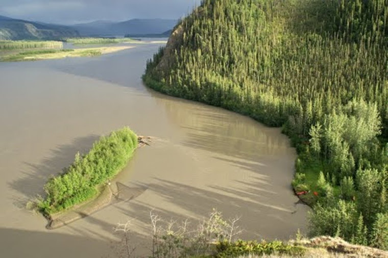
The Upper Yukon River is generally pretty flat, but fast flowing at 4-8 mph on average. The fast current can create dangerous eddies, boils, and whirlpools. The river also carries a tremendous amount of suspended silt which gives the water the appearance of flowing mud. Canoeing this stretch of river will be enjoyable, but avoiding capsize is a must. There are two rapids, Five Fingers and Rinks, neither of these should pose too much of a challenge if run correctly. Much of the time the river flows between fairly high banks, but camping spots are not hard to find. At the Village of Circle there is a change in terrain called the Flats. The Flats are, well, flat. The river is broad and multi-channelled. If I choose the wrong channel, I may find the water is very slow and shallow requiring pulling of the canoe.
I will begin my paddling on the Yukon River at it's source which is in part Lake Bennett after the Chilkoot Pass. I will be timing my arrival here to coincide with when the ice clears from these upper lakes and the river itself. As I paddle downstream, the river will continue to swell in size as other rivers and streams join the Yukon. 2300 miles later (the same length as the Mississippi River), the Yukon River ends at the Bering Sea. The first 900 miles is what I refer to as the Upper Yukon River.
The Upper Yukon River is generally pretty flat, but fast flowing at 4-8 mph on average. The fast current can create dangerous eddies, boils, and whirlpools. The river also carries a tremendous amount of suspended silt which gives the water the appearance of flowing mud. Canoeing this stretch of river will be enjoyable, but avoiding capsize is a must. There are two rapids, Five Fingers and Rinks, neither of these should pose too much of a challenge if run correctly. Much of the time the river flows between fairly high banks, but camping spots are not hard to find. At the Village of Circle there is a change in terrain called the Flats. The Flats are, well, flat. The river is broad and multi-channelled. If I choose the wrong channel, I may find the water is very slow and shallow requiring pulling of the canoe.
Upper Yukon River

Upper Yukon River
Yukon River
Further Downstream
"The Flats"
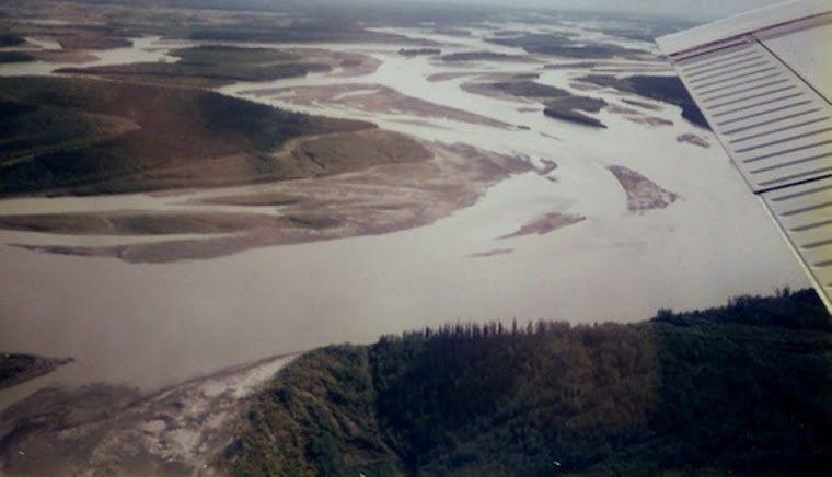
"The Flats"
Adventure Description- Chandalar River
Chandalar River Route and Tundra Portage:
I will leave the relative ease of paddling down the Yukon River at the confluence of the Chandalar River. This leg of the Adventure will require paddling against the strong currents of the Chandalar River to move upstream on this 150 mile stretch. An Alaskan hunting guide familiar with the Chandalar told me he didn't think it posssible to paddle against the current. Where the current is too strong to paddle, I will pull the canoe using the "lining" method. Lining a canoe is accomplished by tying a rope to the bow and another rope to the stern and pulling both ropes at the same time. The canoe can be steered out into the the river by adjusting the length of the ropes as I'm pulling/walking upstream. The Chandalar River is remote even by Alaskan standards and not much information is available. I will eventually take the West Fork branch to unnamed forks of the river until it becomes a trickle of water and portage from there.
The portage from here will be by bushwacking across the tundra and will require finding the best route through the tundra and Brooks Range foothills- there are no portage trails here. The "here" or starting point will be determined by river water levels. I'm hoping that the length of the portage will not be more than 15 miles but it could be as long as 25 miles. Walking on tundra is no fun! It is like walking on a wet sponge with a maze of raised grass hummocks and areas of almost impenetrable brush and stunted black spruce. My destination is the Koyukuk River drainage- either a navigable creek or the River itself.
Chandalar River Picture
Chandalar River
Adventure Description- Koyukuk River
Koyukuk River Route:
I will be glad to be back in my canoe as I travel down the South Fork of the Koyukuk River. After a days travel, I will stop at the site of my cabin that I built and lived-in back in 1989. I am curious to see what has become of my cabin. Paddling this stretch of the Koyukuk will be hard on the canoe bottom because of the shallow, rocky riffles where the water depth is only a couple inches deep. My previous experience here resulted in severely-damaged canoe bottoms. My old fiberglass constructed canoe would only make a few river miles before wearing through. I'm counting on my Sea Wind kevlar hull to perform better on this trip.
According to an experienced Alaska river paddler, the South Fork of the Koyukuk should not be considered for paddling because of the abundance of "sweepers" downstream from the haul road (Dalton Highway). Sweepers are trees that have fallen into the river but their roots are still attached to the bank. They are very effective at catching floating debris (or canoes) from the river water and not releasing them because of the force of flowing water. The Middle and North Forks are the preferred paddling routes, but that is not where my cabin is. Another warning that I can attest to in this part of Alaska- do not have any exposed skin because the mosquitoes are thick!
After the South Fork joins the main channel of the Koyukuk, paddling will be easier for awhile until reaching the lower sections. In the lower section the river enters a vast swampy region known as the "sloughs". River current diminishes to zero through the interconnected sloughs and dead-end oxbow lakes. Locals say that only one or two people per year paddle this part of the Koyukuk. Wildlife is said to be everywhere in this secluded remote section.
Koyukuk River

The South Fork of the Koyukuk River. Photo taken from my 1989 trip.
Koyukuk Cabin
My cabin on the Koyukuk River
Adventure Description- Lower Yukon River
Lower Yukon River Route:
I will return to the Yukon River at it's juncture with the Koyukuk River. I will paddle the remainder of the Yukon River to the Bering Sea. The mighty Yukon is wide along this stretch and is subject to wave action just like a large lake. Crossing the Yukon can be dangerous so I will pick a bank and stick near it as much as possible. The total length of the Yukon is about the same as the Mississippi River.
I will return to the Yukon River at it's juncture with the Koyukuk River. I will paddle the remainder of the Yukon River to the Bering Sea. The mighty Yukon is wide along this stretch and is subject to wave action just like a large lake. Crossing the Yukon can be dangerous so I will pick a bank and stick near it as much as possible. The total length of the Yukon is about the same as the Mississippi River.
Adventure Description- Bering Sea to the End
Final Routes (Kind 0f):
The last four legs of the adventure will be to paddle 1000 miles of Bering Sea coast to Kvichak River, paddle up the Kvichak River to Iliamna Lake, portage across a mountain pass to get to Cook Inlet, and finally paddle the Cook Inlet to Anchorage. The Bering Sea coastline will be a formidable challenge. I was unable to learn of anyone who has paddled this coastline in my research. Limited landing sites, vast tidal mud flats, and, of course at times, nasty sea conditions are some of the obstacles to contend with.
I will be relieved to be off the Bering Sea as I paddle against the current of the Kvichak River that flows out of Iliamna Lake. Iliamna Lake is a huge lake (8th largest in North America) even though it looks small on the Alaska maps. It always amazes how vast and enormous Alaska is.
After portaging my gear again, I will make it into the Cook Inlet that leads to Anchorage. I was hoping that this last leg of the trip would be easy, but that's not the case. More mud flats and huge tidal swings over 30 feet await me. My original goal was to reach Anchorage in mid November but have decided to paddle harder and make it there in early October. Mission accomplished, but if I still feel up to it, I may paddle back to Juneau along the Gulf of Alaska. This would add over 800 miles more to the adventure.
But......
BeaV's Tracking Map
Post Description
Below are my blog posts with the most recent on top. Click on "Older Posts" at the bottom of postings to see older hidden posts.
Sorry things aren't going as planned :( I am so thankful you met Doug and he told you about the conditions. I know you must be itching to keep going but we are all glad you are making a "plan C". Keep us posted on your plan and conditions! We love your updates!
ReplyDeleteFriend wait till the time is right to move up the slope,after that it all down hill.You can make up time on the river fast flow of spring. Watch for sweepers on the rivers and Godspeed.
ReplyDeleteWill
You probably know this, but the train from Skagaway to Bennett should start late May. Maybe a plan Z. Good luck, we have been watching from the start.
ReplyDeleteBob, we really enjoyed meeting you yesterday & having you over to share our dinner at Pullen Creek RV in Skagway, where we are currently parked while we work for the cruise ship season here. Your blog & photos make good reading. We will try to follow your progress when you finally move on to tackle the Chilkoot Trail. Good luck to you. Barry & Corinne
ReplyDeleteBob, just wait it out another week or so until the rangers and trail crews can get up there; take a break (you deserve it). Get a ride up to Log Cabin and practice on snow shoes for an afternoon. However, if the pass remains dangerous, there is no surrender by playing it safe and loading canoe and gear on the train up to Bennett on May 28 or whenever that service starts and putting in on the lake. Usually the ice will go out on Bennett and the rest of the lakes by the the first week of June. If you get to Whitehorse by June 10, you can still make the Bering by early August. Most paddlers doing the whole river this summer will be arriving in Whitehorse about that time. You'll see them hanging out at outfitters Kanoe People and Up North. Stop by the SkagNews and let's chat. - Jeff
ReplyDeleteBeaV, you are getting a lot of good advice here that all says: wait it out or take the train. Believe me, even if you take the train, no one is going to think you copped out. You are on an amazing and unique adventure and responding properly to the conditions that confront you is part of that adventure.
ReplyDeleteWe watch you continue to be safe and smart. Keep it up.
Jerry (OneMatch)
Hi Bob! Been watching your progress as well as a friend of mine in Anchorage. She too said bad conditions and hoping for slow melt to prevent flooding. Stay safe and you have a lot of us rooting for you back here in MN!
ReplyDeleteYour cousin Jenny :)